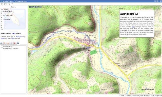
QLandkarte GT is the ultimate outdoor aficionado's tool. It supports GPS maps in GeoTiff format as well as Garmin's img vector map format. Additional it is the PC side front end to QLandkarte M, a moving map application for mobile devices.
Project Samples
Categories
GISLicense
GNU General Public License version 3.0 (GPLv3)Follow QLandkarte GT
You Might Also Like
Venn is a secure workspace for remote work that isolates and protects work from any personal use on the same computer. Work lives in a secure local enclave that is company controlled, where all data is encrypted and access is managed. Within the enclave – visually indicated by the Blue Border around these applications – business activity is walled off from anything that happens on the personal side. As a result, work and personal uses can now safely coexist on the same computer.
Rate This Project
Login To Rate This Project
User Reviews
-
Excelente aplicación para trabajar con datos GPS en linux. Permite extraer datos almacenados, navegar en tiempo real, crear nuevos waypoints, tracks, rutas y enviarlos al dispositivo. Me funciona excelente con mi Garmin GPSmap 76Cx en OpenSuse Leap 42.2.
-
Hi Visit the blog "Zona OpenGTS" (www) zona-opengts.blogspot.com Thanks !!!
-
How can someone rate this project with only one star?? Even Garmin staff should be happy with this, letting us (linux users) handle garmin devices, instead of others'.
-
Why is this happening? Version 1.5.0 htt p://www.lv-bw.de/dv/service/getrds.asp <?xml version='1.0' encoding='UTF-8' standalone='no'?> <!DOCTYPE ServiceExceptionReport SYSTEM 'htt p://schemas.opengis.net/wms/1.1.1/WMS_exception_1_1_1.dtd'> <ServiceExceptionReport version="1.1.1"> <ServiceException code="GC-Parameter-Fehler">GetCapabilities-Request unvollstaendig: GC-Parameter fehlt oder fehlerhaft</ServiceException> </ServiceExceptionReport>
-
Qlandkartegt works perfectly.