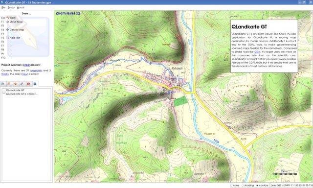
QLandkarte GT is the ultimate outdoor aficionado's tool. It supports GPS maps in GeoTiff format as well as Garmin's img vector map format. Additional it is the PC side front end to QLandkarte M, a moving map application for mobile devices.
Project Samples
Categories
GISLicense
GNU General Public License version 3.0 (GPLv3)Follow QLandkarte GT
Other Useful Business Software
CODESOFT is an enterprise-level RFID and barcode label design application offering unmatched flexibility, power, and support. Available in print-only, single-user, and network configurations, CODESOFT is designed to meet all of your barcode labeling needs. Whether your goal is streamlining label printing, printing labels using a form, connecting a scale to your label template, or integrating your business database with your label templates, CODESOFT provides a solution for your organization’s most advanced labeling needs. Connect to SQL or Oracle databases for business system integrations and greater efficiency. CODESOFT includes over 100 barcode symbologies including GS1, supports all common image formats, and enables rich text editing. Native printer drivers are included for over 4,000 thermal, thermal transfer, and inkjet label printers to ensure the best label printing quality.
Rate This Project
Login To Rate This Project
User Reviews
-
Excelente aplicación para trabajar con datos GPS en linux. Permite extraer datos almacenados, navegar en tiempo real, crear nuevos waypoints, tracks, rutas y enviarlos al dispositivo. Me funciona excelente con mi Garmin GPSmap 76Cx en OpenSuse Leap 42.2.
-
Hi Visit the blog "Zona OpenGTS" (www) zona-opengts.blogspot.com Thanks !!!
-
How can someone rate this project with only one star?? Even Garmin staff should be happy with this, letting us (linux users) handle garmin devices, instead of others'.
-
Why is this happening? Version 1.5.0 htt p://www.lv-bw.de/dv/service/getrds.asp <?xml version='1.0' encoding='UTF-8' standalone='no'?> <!DOCTYPE ServiceExceptionReport SYSTEM 'htt p://schemas.opengis.net/wms/1.1.1/WMS_exception_1_1_1.dtd'> <ServiceExceptionReport version="1.1.1"> <ServiceException code="GC-Parameter-Fehler">GetCapabilities-Request unvollstaendig: GC-Parameter fehlt oder fehlerhaft</ServiceException> </ServiceExceptionReport>
-
Qlandkartegt works perfectly.